title img


oldenburg

Dr. Doug Oldenburg is presenting the Society of Exploration Geophysicists 2017 Distinguished Instructor Short Course on Geophysical Electromagnetics: Fundamentals and Applications . DISC 2017 will be held in ~30 locations around the world , and will cover applications of electromagnetic geophysics across mining, oil and gas, geotechnical, water and environmental industries.


why

Electromagnetics can be diagnostic for ...

Applications of Electromagnetics

Are you ___________?

exploring

  • mineral deposits
  • oil and gas reservoirs
  • groundwater aquifers
  • geothermal reservoirs
  • ...

monitoring

  • sea water intrusion
  • enhanced oil recovery
  • hydraulic fracturing
  • carbon sequestration
  • ...

characterizing

  • slope stability
  • unexploded ordnance
  • environmental remediation
  • nuclear waste storage
  • ...

Interested in exploring how EM can contribute to a solution?

who

DISC 2017 is intended for

  • Practitioners in academia or industry who want to use EM data to answer geoscience problems
  • Industry geoscientists (geophysicists and geologists) who are not familiar with EM and its applications
  • Graduate students and academia even if they have never used EM
  • Researchers who want to carry out forward modelling and inversion of EM data.

Instructors

who img
Doug Oldenburg

Doug is a professor of Geophysics, director of the Geophysical Inversion Facility (GIF) and world leader in geophysical inversions. He is dedicated to making geophysics more useful for solving problems of relevance to society. Doug’s research career has focused upon the development of inversion methodologies and their application to solving applied problems in a variety of fields. Motivated to make geophysics more accessible and engaging, he has and continues to lead efforts for distributing software codes and learning resource material for students and practising geoscientists.

who img
Lindsey Heagy

Lindsey's thesis work focuses on using electromagnetic geophysics for monitoring subsurface injections, including carbon capture and storage and hydraulic fracturing. She a project lead on GeoSci.xyz, an effort to build collaborative, interactive, web-based textbooks in the geosciences, and SimPEG, an open source framework for geophysical simulation and inversions.

who img
Seogi Kang

Seogi's PhD research focuses on developing a numerical workflow to extract three-dimensional chargeability information from airborne electromagnetic (AEM) data. He is developing a worklow to obtain chargeability information from AEM data, and applies this workflow to delieneate diamondiferous units in a kimberlite deposit in northern Canada. Seogi is a core contributor to SimPEG.

DISC course

course img

Fundamentals

Maxwell’s equations connect EM fields and fluxes with physical properties: electrical conductivity, magnetic permeability and dielectric permittivity. Understanding the relationship between the transmitter, physical properties and data is key to success. Learning is promoted with interactive application software.

&

course img

Applications

Exploration (minerals, hydrocarbons, water, geothermal energy), environmental (salt water intrusion, contaminant spills, UXO) and geotechnical (slope stability, near-surface geology) problems are addressed through case histories, each of which is presented in a Seven-Step process.


Goals

  • Inspire geoscientists to explore if EM geophysics can be relevant to their problem

  • Build a foundation for choosing an appropriate survey based upon knowledge of physical principles

  • From physical principles, set realistic expectations for what information you might be able to extract from a survey

Content

Case histories are the underlying framework used to bind the material together. Each case history is presented in a seven-step process that begins with the description of the geologic or geophysical problem to be solved, and ends with the impact of the EM geophysical survey to help solve the problem. At intermediate points, we investigate the details of the particular EM survey, some fundamentals of electromagnetic induction, and processing/inverting the data. The ability to move seamlessly between these different levels of information, so that relevant questions or concepts can be addressed, is facilitated by the open-source resource em.geosci.xyz.

seven-steps

Although we work continually with Maxwell’s electromagnetic equations, the presentations are mathematically “light” and the learning aspect is facilitated by the use of Jupyter notebooks. These provide an interactive computing environment in which you can ask 
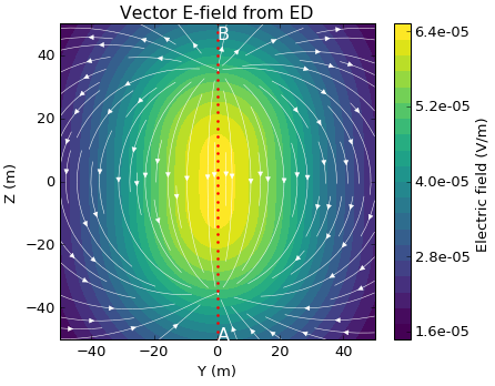
questions and explore concepts. As an example, 
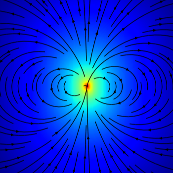
you are invited to use the Electric Dipole Notebook that allows you to explore the EM fields for an electric dipole in a cross-well survey using frequencies that range from DC to those used in a radar survey.

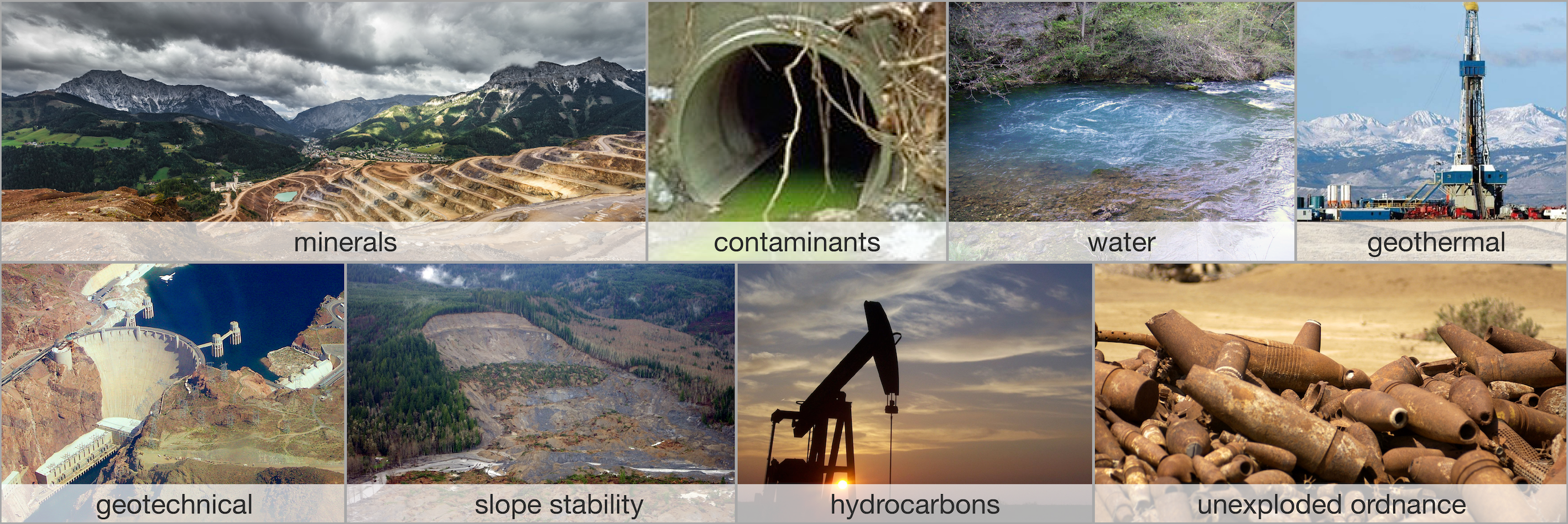
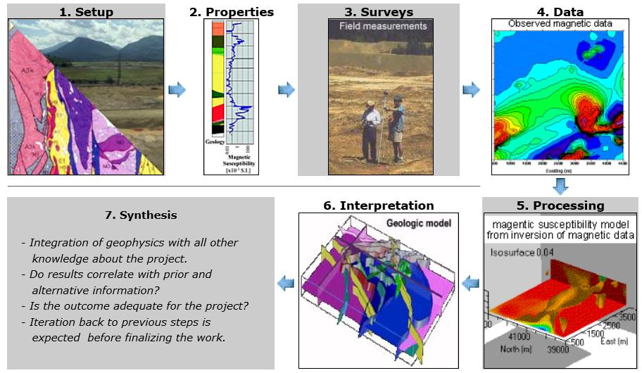
The case histories pertain to problems in resource exploration, environmental, and geotechnical areas and are contributed by experts worldwide. We successively look at surveys that make use of 
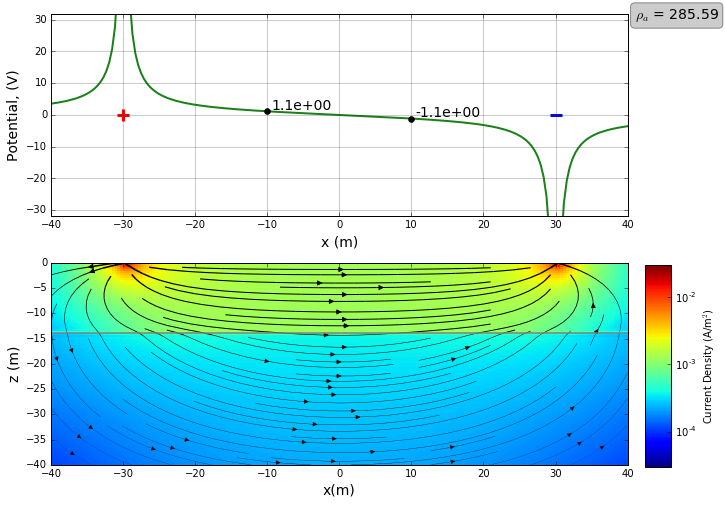
steady state fields (DC resistivity, IP, MMR), and then move on to FDEM (frequency domain) and then to TDEM (time domain). The energy sources for these surveys are both man made and natural. The latter allows us to explore MT and ZTEM surveys. The various surveys can be carried out in the air, on the earth’s surface or underground and the case history determines which survey is selected. The choice of case histories and surveys to focus on depends upon the location at which the DISC is presented and the problems that are of general interest to that location. This is why we are requesting locally generated case histories.

It is not possible to cover all of EM geophysics in a single day but attendees will obtain new insight about EM fundamentals and applications. The DISC, and the associated open source resources, can then act as a catalyst to develop a community that can share information, interact on EM problems of mutual interest, and elevate the use of EM geophysics to solve applied problems.

For more, see the Interview with Doug.


DISC lab

The DISC Lab days are designed for a smaller group of geoscientists. We ask participants to provide informal 5 min lightning talks about problems of local interest. We will then work as a group to break down the problems in terms of the 7-Step Framework introduced in course. If participants agree, their talks and results from discussions, will be uploaded to the web. By capturing these problems and state-of-progress onto the web, we hope to promote interaction between geoscientists worldwide. Tutorials on simulations and inversions are also available upon request. There is no registration fee for DISC Lab.


where

DISC 2017 where

The 2017 DISC is organized in 6 legs. Tentative locations are shown, these are subject to change based on interest. Get in touch if you would like DISC 2017 to come to a city near you!


resources

em.geosci.xyz

EM GeoSci is the primary reference for the 2017 DISC. It is open source and a part of the GeoSci.xyz project. This replaces the textbooks typically used for DISC courses.

apps

Interactive numerical simulations are available as Jupyter Notebooks. They are built on the open source package SimPEG and can be downloaded from github.

contribute

We want your case histories!


connect